

Mammatus Clouds - Mammatus are pouch-like cloud structures and a rare example of clouds in sinking air. Sometimes very ominous in appearance, mammatus clouds are harmless and do not mean that a tornado is about to form - a commonly held misconception.


Noctilucent Clouds - Noctilucent Clouds or Polar Mesopheric Clouds: This is an extroadinarily rare cloud formation that occurs out on the verge of space between 82km to 102 km from the earth’s surface. Noctilucent clouds appear to be luminous yet they reflect the sunlight from the other side of the earth at night, giving them a glowing appearance.


Mushroom Clouds - A mushroom cloud is a distinctive mushroom-shaped cloud of smoke, condensed water vapor, or debris resulting from a very large explosion. They are most commonly associated with nuclear explosions, but any sufficiently large blast will produce the same sort of effect. Volcano eruptions and impact events can produce natural mushroom clouds.


Shelf Clouds - A shelf cloud is a low, horizontal wedge-shaped arcus cloud, associated with a thunderstorm gust front . Unlike a roll cloud, a shelf cloud is attached to the base of the parent cloud above it (usually a thunderstorm). Rising cloud motion often can be seen in the leading part of the shelf cloud, while the underside often appears turbulent, boiling, and wind-torn.


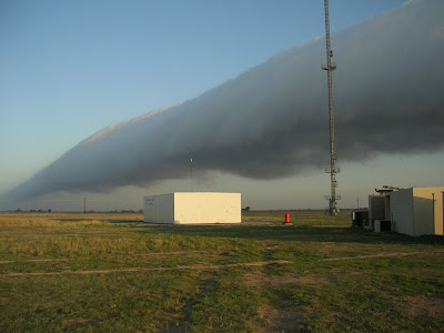
Roll Clouds - A roll cloud is a low, horizontal tube-shaped arcus cloud associated with a thunderstorm gust front, or sometimes a cold front. Roll clouds can also be a sign of possible microburst activity. Cool air sinking air from a storm cloud’s downdraft spreads out across the surface with the leading edge called a gust front. This outflow undercuts warm air being drawn into the storm’s updraft. As the cool air lifts the warm moist air water condenses creating cloud, which often rolls with the different winds above and below


Really, these clouds are very beautiful.
ReplyDeleteThanks for share....
so beautiful, i especially love the mushroom cloud on the mountain.
ReplyDeletethanks 4 sharing
sorry but your "Mammatus Clouds" also called "mammals" are very dangerous for airplanes of all kinds.
ReplyDeleteThe winds in mammals clouds can be extremely turbulent and rip the wings of jets like nothing...
even fighter jets are most likely to not come out in 1 piece..
Very Nice Clouds especially like your Noctilucent Cloud examples but a few points of correction:
ReplyDeleteThe cloud above the mountain in the first picture you have labled in the mushroom cloud group is not a mushroom cloud at all, but a very large lenticular cloud , formed by the compression of winds passing over the mountain or over a thunderstorm updraft. They are so named for their lens shape... hence the name lenticular.
(See http://en.wikipedia.org/wiki/Lenticular_cloud )
Also mushroom clouds in thunderstorms are more appropriately named cumulonimbus or commonly called thunderheads or anvil clouds.
(See http://en.wikipedia.org/wiki/Cumulonimbus_cloud )
Also to the person commenting on the mammatus pictures calling them mammals clouds, you must be mistaken or heard this wrong as they are definitely mammatus not mammals. They are clearly named for the shape as they look like the mammary glands on a woman who happens to be a mammal but not named for mammals themselves. However the mammatus do pose a substantial threat to airplanes and their passengers because they signify great turbulence within the atmosphere in and around the clouds. They are usually indicative of severe weather in the proximity of them as well, however i think a jet would typically remain in one piece but face turbulence or loss of lift that may certainly put any plane or its passengers in
peril. (See http://en.wikipedia.org/wiki/Mammatus_cloud )
Don't mean to be nit-picky but do mean to put things in their proper classification as I am actually a meteorologist.